Wednesday, August 30, 2017

Sea Serpent or Shipwreck?

I love to walk, and when I'm walking I carry my cell phone. Sandwich is a beautiful town, and sometimes I snap a few photos. I walk in my neighborhood. I walk along the canal. I walk from the library, past Town Hall, and over to Wing School. And sometimes I park at the Sand Hill School and walk to the boardwalk. Close to the Sand Hill School, Dock Creek flows under Dewey Avenue and meanders through the salt marsh toward Town Neck Beach. High tide regularly floods the marsh. Low tide exposes rotted wooden posts that project from the mud like the skeletal teeth of a long-deceased  sea serpent or the hull of a decaying shipwreck.


Dock Creek at low tide.

Ruling out sea serpent, I wondered if, perhaps, a long time ago, some kind of ship had sunk in the creek.

Recently while reading my emails, I came across an announcement from Bridgewater State University's Cape Cod campus. Dr. Calvin Mires, a marine archaeologist, was coming to speak at the South Yarmouth campus about shoreline shipwrecks. Dr. Mires investigates not only shipwrecks, but also wharves, seaside communities, and maritime landscapes.

Dr. Calvin Mires offers educational and training opportunities to citizen
scientists of all ages in Massachusetts.

Perfect, I thought. Just the man to answer my questions about Dock Creek. But when I checked my calendar, I realized I couldn't go to his talk. So I emailed him instead, attaching my photo of the creek bed along with an aerial photo of the marsh.

Dock Creek appears under the letters www. 

While I waited for Dr. Mires's response, I stopped by the Wing Fort House on Spring Hill Road, another nice place to walk, and talked to caretaker and  archaeologist Dave Wheelock. 

"Some Sandwich natives think those rotting pieces of wood could be the remains of the Sandwich glass museum's dock," Wheelock said. So that could be how the creek earned its name, I realized. "But others think the wooden posts could be what's left of some old fishing shacks," he added. Both explanations made sense. Dock Creek is close to the site of the 19th century glass museum, and fishermen frequent the area.

A couple of weeks passed before Dr. Mires responded to my email, and he seemed quite interested in my photos. He wrote that a friend had mentioned Sandwich's cultural resources, and he had already visited Sandwich to search for possible archeaological sites. But he didn't discover Dock Creek. "Your photos provide wonderful information," he wrote. "I have some immediate thoughts, but honestly with so little uncovered it is premature to say. I would enjoy seeing these features in the near future."

We arranged to meet early on a sunny morning when the tide was low.

Dr. Mires clambered over the guard rail that separates the road from the creek and strode through the marsh in worn sandals. He located a couple of raised areas and kicked at the flattened marsh grass. Underneath were piles of old bricks. He looked around, surveying the area. "This must have been a dock for the glass factory," he decided. "They probably loaded shipping crates onto small boats or barges that carried the crates to deeper water where larger ships were waiting. The rotted wood structures were probably posts or pilings that held up the dock."


As we were leaving, he picked up a rotting board with a metal piece attached to it. "I can tell you with certainty the age of this piece," he said. "The metal was made in the late 1800s. It was probably part of an old bridge."


I thanked Dr. Mires for his visit, and we talked about a project he's involved with now at Pilgrim Hall, the reconstruction of the 1626 Sparrow-Hawk shipwreck, discovered Orleans in 1862.

According to Pilgrim Hall's website, "After being wrecked in 1626, the Sparrow-Hawk was buried in sand and mud in a part of Orleans later known as "Old Ship Harbor." The timbers were visible from time to time until 1862, when they were uncovered in a great storm. The ancient hull was removed and reassembled."

Another quest for another time? Hopefully, yes.

Friday, August 18, 2017

On the Trail of William Wood, One of Sandwich's Ten Men

There are times when I'm in the midst of writing about history that I wonder why I chose this task. Why didn't I choose to write about someone who's actually living and breathing? Someone like Taylor Swift, Michelle Obama, Jennifer Lawrence, Robert Downey, Jr., or even Brad Pitt? 
      

          I envy authors who write current biographies. They can search the internet for news articles. They can read People magazine with its juicy gossip and glossy, color-saturated photos. And, of course, they can arrange to interview their glamorous subjects in fancy restaurants where they can sit in comfortable chairs and talk and laugh and share numerous bottles of expensive red wines. But after gathering dry facts from dry history books and poring through dusty archive files containing the occasional grainy photo, a historical biographer like me can only get to know her subject by using her imagination. 

          After reading more than a few history books, I still knew relatively little about my subject, William Wood, other than that he was one of the Ten Men of Saugus who founded the town of Sandwich in 1637. There were no cameras back then, and no one painted a portrait of him. He was about twenty when he came to America, and he must have dressed like a Pilgrim or a Puritan. Maybe he looked something like this:

          Not exactly sexy. Definitely not Brad Pitt. But William Wood was an author, and for me, that's cool. He wrote New England's Prospect, and he was also Sandwich's first town clerk. 

          Town clerks write. They record marriages, births, and deaths. It makes sense that the early settlers would have chosen Wood to be town clerk because he liked to write - and he was good at it; he had written and published a book. I knew it would be hopeless to find any artifacts that Wood left behind; something like that wouldn't help me much anyway. But I wondered if I might be able to find a document he wrote. 

          Historic imagination has to be fueled by facts gleaned from documents and artifacts. Documents contain written words. Artifacts are things made by human beings, things like arrowheads and blunderbusses, wooden butter churns and pocket watches, 45mm record players and Model T Fords. Artifacts like these reveal a lot about how things were done at the time the artifact was made. Very old documents are also considered artifacts because historians can learn a lot from them about how things were done during the time when they were written.

          To feed my historical imagination, I visited Plimoth Plantation and talked to the young man who portrays Governor William Bradford in the English village to get an idea of what writing was like in the 1600s. Back then, girls were rarely educated, and those few Pilgrim and Puritan boys who learned how to write used goose-quill pens they made themselves and ink brought to them on ships as they arrived with more settlers from England. Lacking dictionaries, writers were creative spellers, and they formed their letters differently. For example, an f-shaped s was used when the letter s was doubled or used initially. Common abbreviations included wt for with, yt for that, and ye for the.


Plimoth Plantation's Governor William Bradford pens his journal, Of Plimoth Plantation. Notice the ink pot and quill pen.

First page of Governor Bradford's journal. How many misspellings can you find?

Sandwich's Town Hall Annex houses the Town Clerk's office.


          Next I went to Sandwich's town clerk's office on Main Street where some of the oldest documents in Sandwich history are locked in a walk-in safe.

          Sandwich's town clerk is Taylor White. Interestingly, Mr. White has an active interest in preserving town records and making them available to the public through his office. He is creating an electronic searchable database for 75% - 85% of Sandwich's vital records (marriages, births, and deaths) dating back to the early 1650s. He has already finished up to 1885, crosslinking the digital data to images from a book of records published by the New England Historic Genealogical Society, an organization that helps family historians. Eventually genealogists will be able to visit Mr. White's office to search for information about their ancestors.
Sandwich's vital records are published in several volumes like this one.

          In the photo below, Mr. White is holding a book of restored documents dating back to 1650. This book contains documents from the early 1650s, when William Wood was living in Sandwich.

Town Clerk Taylor White
          After Mr. White handed me the book of documents, I set it on a side table and began flipping through the pages, looking carefully at the dates. I knew that William Wood sold his Sandwich property sometime in the spring of 1650, so if I wanted to find something he wrote as town clerk, it would have to be dated before then. It didn't take me long to find what I was looking for.

Jan. 4th, An. [in the year]1650  It is agreed upon by the towne to pay unto Richard Bourne 20 shillings... in consideration of his labour and paines that he has taken in businesse concerning the towne... 

          This document most likely was penned by William Wood. Hurrah! 

          Besides imagination, historians are infected by another disease of the mind and heart, and that disease's name is Curiosity. Now that I had found a document written by William Wood, I wondered what his signature might look like. “I think, at a child's birth, if a mother could ask a fairy godmother to endow it with the most useful gift, that gift would be curiosity,” said Eleanor Roosevelt. But most of us also remember that curiosity killed the cat. It can also bring great surprises and deep disappointment. Even though he's not Brad Pitt, I hope you'll continue to read the next installments of my blog to discover what surprises and disappointments were in store for me as I contined to delve into William Wood's life story. 

Helpful Link for the Curious:

For more on early 17th century penmanship: http://www.rootsweb.ancestry.com/~mosmd/pilpen.jpg 

Saturday, August 12, 2017

Why the Wrong Spelling Can Sometimes Be Right, or How Mapmakers Collaborate


In the beginning God created the heaven and the earth. And then, in 1507, Martin Waldseemüller did his best to map it.
"A Map of the World According to the Tradition of Ptolemy and the Voyages of Amerigo Vespucci," 1507
Waldseemüller's map is huge, 54 x 96 inches, and it's famous, not because he was the first to try to draw the world, but because he wrote the word America on the continent we call South America. Waldseemüller obviously had no idea how big North and South America actually are, but he got a lot right compared to past mapmakers.


How did Waldseemüller figure out how to draw his map? He wasn't a surveyor, he didn't have satellites or a GPS, and he had never travelled very far from his homeland, Germany. But he studied maps drawn by others and listened to explorer's stories.  In particular, he paid attention to a story told by explorer Amerigo Vespucci, who proposed in a letter that the lands Columbus discovered were a “New World, because none of those countries were known to our ancestors . . . I have found a continent in that southern part more populous and more full of animals than our Europe or Asia or Africa.”

Fast forward a hundred years, and along came John Smith, an Englishman who earned his fame in Jamestown, Virginia, explored the New England coast, and mapped New England from Maine south to Cape Cod, among other accomplishments. To draw his map, Smith probably used a compass, astrolabe, sextant, and a lead line to measure ocean depth.

astrolabe
compass

sextent
John Smith's 1616 map, New England Observed
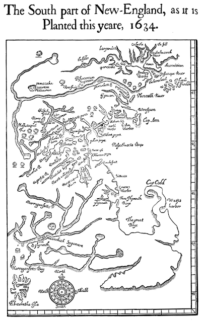
Before William Wood's 1629 voyage to Salem, historians believe he probably saw and studied John Smith's map, and then in 1634, he drew his own.


As far as we know, Wood never drew any other maps, and he probably wasn't a surveyor or mapmaker. So how did he draw such a relatively accurate map? I didn't have a clue until one day when I happened to randomly enter the title of Wood's book, New England's Prospect, into a google search bar. Fortunately, I mispelled the title, omitting the apostrophe and s, and this is what I found: New England Prospect: Maps, Place Names, and the Historical Landscape, a periodical, it turned out, that's available only in a few places, including Brown University. A few days after I made that accidental spelling mistake, I drove to Providence, Rhode Island to do some investigating.

John Carter Brown Library, Brown University, Providence, RI


Interior, John Carter Brown Library

I called ahead, so it didn't take long for the librarian to deliver this booklet to me.


And inside, this is what I found:


Map of Boston area drawn by unknown surveyor for Governor John Winthrop, 1633,
with notations written by the governor.

"A map of considerable importance in understanding the early toponymy [place names] of eastern Massachusetts is Governor John Winthrop's manuscript plan of the Bay Colony plantations, apparently drafted in 1633 and thus probably the basis for the noted William Wood map in New England's Prospect of 1634. The Winthrop plan depicts the overlap between native and English settlement with great accuracy. Clearly shown are the Indian wigwams on the Mystic and Neponset Rivers with the Puritan plantations set along the Charles River from Boston to Watertown," wrote Professor Arthur J. Krim.

I like to imagine the people William Wood met in his travels. Was Prof. Krim suggesting that William Wood met with Governor Winthrop and looked at his map before drawing his own? It seemed to me to be so.

Governor John Winthrop, 1587 - 1649


For more about Martin Waldseemüller's map: 
http://cartographic-images.net/Cartographic_Images/310_1507_Walds.html 

For more about John Smith: 
http://www.smithsonianmag.com/history/john-smith-coined-the-term-new-england-on-this-1616-map-180953383/#OXIxbhPMuP27qcRo.99

John Smith's map: 
https://www.penobscotmarinemuseum.org/pbho-1/collection/john-smiths-map-new-england-1616

For more about Governor Winthrop's map: Narrative and Critical History of America by Justin Winsor, Vol. 3, published by Houghton Mifflin in 1884, note on page 381. (Professor Krim referred to Winsor.)
https://archive.org/stream/narrativecritica03wins#page/n0/mode/1up


Tuesday, August 8, 2017

The Cratchets at Plimoth Plantation

Bob Cratchit and Tiny Tim from the TV cartoon Mr. Magoo's Christmas Carol came to mind today while I was visiting Plimoth Plantation. Remember Tiny Tim's wooden crutch? It looked like it was cut from the forked branch of a tree.

Image result for tiny tim and cratchit

I visited the Pilgrim village because I was trying to get an idea of what life must have been like for Sandwich's founding fathers, William Wood in particular. When Wood left Sandwich in 1650, he sold his house and land to James Skiffe. According to the deed, Wood's property included "...one barne and staules for cattle adjoined thereunto together with... upland and meadows, tilled or untilled, fenced or unfenced... and also all the dounge and mannure alreddy made..." Wood was a farmer who, like most farmers of this time, kept animals like sheep, pigs, goats, chickens, and cattle. He also owned eight acres of marshland between his house and what is today Town Neck Beach.


 Cattle near a Gate, Saltholm 

by Theodor Philipson (1840 - 1920)


Having seen English paintings of cattle grazing by the sea, I was curious to know if farmers like Wood allowed their cattle to graze on the marsh.


In the village's fort, I met Bill Rudder, who seemed to know lot about the village's cattle, and he recommended that I search through Plimoth Plantation's website to find the 1627 Plimoth Colony Division of Cattle that names each one of the colonists, adults and children, the cattle they owned, and often the name of the ship that transported each of the cattle. Thus, "The fourth lot fell to John Howland & his company Joyned to him his wife To this lot fell one of the 4 heyfers Came in the Jacob Called Raghorne." (Jacob was the name of the ship and Raghorne the cattle's name.) And "The eleventh lott ffell to the Governor Mr William Bradford and those with him, to wit, his wife To this lott fell An heyfer of the last yeare wch was of the Greate white back cow that was brought over in the Ann..."

"Did cattle actually graze on salt hay?" I asked Bill. 

"Yes," he nodded. "If fact, because the cattle would sink in the marsh mud, farmers would attach wooden shoes to their hooves."
Bill Rudder, Plimoth Plantation's Manager of Historical Built Landscapes

Turns out Bill has been working at Plimoth Plantation for twenty years, and he manages the construction of the historical landscapes there. He happened to be touring the village with a high school student who would soon be taking on the role of eighteen year old Mary Buckett who eventually married Pilgrim George Soule. I was happy to join them as they wandered through the Pilgrim's houses. 

Rose the Red Devon Heifer

"What kind of houses did the earliest settlers build during their first difficult months and years in America?" I asked Bill. But he didn't answer right away. First he showed Mary and me a house that was built with a standard construction method. Then he showed us an example of reverse construction. It wasn't until we found Rose, the village's red Devon heifer, in a fenced-in pasture that Bill showed me what I was looking for by pointing out Rose's rude shelter. 

"That's the kind of building most settlers lived in during their first year," Bill said. "Some constructed wigwams like the natives. Some built lean-tos. But this was built using cratchets that are pounded into the ground."

"Cratchets?" I asked, thinking of Bob and Tiny Tim Cratchit.

"Cratchets," Bill nodded. "Tree trunks with natural forks at the upper end. The Y of the fork is used for support.

In the photo below, you can clearly see the post on the left corner that's holding up a crossbeam and another cratchet that supports the roof's ridge beam. Do they look like Tiny Tim's crutch? I thought so. I also thought it must have been awfully uncomfortable for William Wood and the other early settlers as they adjusted to their new home.

Rose's Shelter