
In the beginning God created the heaven and the earth. And then, in 1507, Martin Waldseemüller did his best to map it.
 |
| "A Map of the World According to the Tradition of Ptolemy and the Voyages of Amerigo Vespucci," 1507 |

How did Waldseemüller figure out how to draw his map? He wasn't a surveyor, he didn't have satellites or a GPS, and he had never travelled very far from his homeland, Germany. But he studied maps drawn by others and listened to explorer's stories. In particular, he paid attention to a story told by explorer Amerigo Vespucci, who proposed in a letter that the lands Columbus discovered were a “New World, because none of those countries were known to our ancestors . . . I have found a continent in that southern part more populous and more full of animals than our Europe or Asia or Africa.”
Fast forward a hundred years, and along came John Smith, an Englishman who earned his fame in Jamestown, Virginia, explored the New England coast, and mapped New England from Maine south to Cape Cod, among other accomplishments. To draw his map, Smith probably used a compass, astrolabe, sextant, and a lead line to measure ocean depth.
 |
| astrolabe |
 |
| compass |
 |
| sextent |
 |
| John Smith's 1616 map, New England Observed |
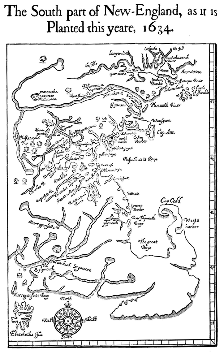
As far as we know, Wood never drew any other maps, and he probably wasn't a surveyor or mapmaker. So how did he draw such a relatively accurate map? I didn't have a clue until one day when I happened to randomly enter the title of Wood's book, New England's Prospect, into a google search bar. Fortunately, I mispelled the title, omitting the apostrophe and s, and this is what I found: New England Prospect: Maps, Place Names, and the Historical Landscape, a periodical, it turned out, that's available only in a few places, including Brown University. A few days after I made that accidental spelling mistake, I drove to Providence, Rhode Island to do some investigating.
 |
| John Carter Brown Library, Brown University, Providence, RI |
 |
| Interior, John Carter Brown Library |
I called ahead, so it didn't take long for the librarian to deliver this booklet to me.

And inside, this is what I found:
 |
| Map of Boston area drawn by unknown surveyor for Governor John Winthrop, 1633, with notations written by the governor. |
"A map of considerable importance in understanding the early toponymy [place names] of eastern Massachusetts is Governor John Winthrop's manuscript plan of the Bay Colony plantations, apparently drafted in 1633 and thus probably the basis for the noted William Wood map in New England's Prospect of 1634. The Winthrop plan depicts the overlap between native and English settlement with great accuracy. Clearly shown are the Indian wigwams on the Mystic and Neponset Rivers with the Puritan plantations set along the Charles River from Boston to Watertown," wrote Professor Arthur J. Krim.
I like to imagine the people William Wood met in his travels. Was Prof. Krim suggesting that William Wood met with Governor Winthrop and looked at his map before drawing his own? It seemed to me to be so.
 |
| Governor John Winthrop, 1587 - 1649 |
For more about Martin Waldseemüller's map:
http://cartographic-images.net/Cartographic_Images/310_1507_Walds.html
For more about John Smith:
http://www.smithsonianmag.com/history/john-smith-coined-the-term-new-england-on-this-1616-map-180953383/#OXIxbhPMuP27qcRo.99
John Smith's map:
https://www.penobscotmarinemuseum.org/pbho-1/collection/john-smiths-map-new-england-1616
For more about Governor Winthrop's map: Narrative and Critical History of America by Justin Winsor, Vol. 3, published by Houghton Mifflin in 1884, note on page 381. (Professor Krim referred to Winsor.)
https://archive.org/stream/narrativecritica03wins#page/n0/mode/1up
No comments:
Post a Comment